1
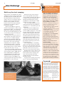
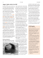
Crossroads
TRANSPORTATION Information Center—LTAP
Fall 2004
University of Wisconsin–Madison
PHOTO CREDIT: R.J. & LINDA MILLER
WISCONSIN DEPARTMENT OF TOURISM
Armoring pavement at snowmobile crossings
Up North, in the
“Snowmobile
Capital of the
World,” snowmobile traffic can
get very heavy.
“It’s like being in
an anthill during
the race,” says Marv Laspa, Operations
Supervisor, WisDOT District 7. “I’ve
been told that at times there are 200
snowmobiles an hour at some crossings!”
All that activity puts a lot of wear on
pavement surfaces and bridge decks from
the snowmobiles’ carbide-tipped studs.
To protect the roads and avoid having to
patch them, Laspa borrowed an idea
from Michigan—gluing durable stone
to the crossing surface with epoxy-like
polymers.
The first surfaces were installed in
2000 at busy Minocqua and Eagle River
crossings. The wear layers worked well,
and others were added throughout the
District’s eight counties. About 50 crossings are now armored. “I think it saves
quite a bit on the pavement,” says Laspa.
“I just can’t imagine what we’d be fixing
on the road if we didn’t have this armor.”
The material costs $1500-$2000 per
crossing to install and lasts several years,
depending on how heavily the trail is
used. The process is pretty “low-tech”
and uses common equipment. Local road
crews can do it themselves. Some important elements are getting very hard stone
(7 on the Mohs scale), having a moderate
air temperature during application, tapering the downstream edge so plow blades
ride over it more easily, and making saw
cuts to reduce pavement cracking.
The materials were originally designed
for use on rigid concrete bridge decks,
where they work quite well. However,
when applied to asphalt, the coatings can
sometimes delaminate. The polymer is
stiffer than blacktop and expands and
contracts differently.
Overall, the snowmobilers seem
happy. The material delineates the crossing, making it easier for drivers—vehicle
and snowmobile—to see. Although there
is some concern about wear to the studs,
as taxpayers the snowmobilers appreciate the savings in road repairs. “It also
reduces the amount of negative sentiment,” Laspa says. Having a level pavement instead of a dip where the surface
was patched helps keep the non-snowmobilers happy, too.
One potential problem is that some
crossings move when a snowmobile club
loses its lease for the trail. It’s important
to have some assurance that the trail will
continue to be used, Laspa notes.
A thermoplastic option
Michigan DOT began studying the coatings in 1997. They identified issues like
potential for snowplow blades to peel
them off, and developed installation
procedures. In 2000 they also learned of
and began testing a different approach:
hot-applied thermoplastic. The material,
imported from Norway, is applied in
three layers with fine-grade silica sand
on top for skid resistance.
The thermoplastic costs about the
same as the polymer, but works better on
continued on page 5
Inside
Idea Exchange
Beloit recycles street sweepings
.....
Signing & pavement marking Q&A
..
2
2
Erosion control techniques updated . 3
.....
4
...........
5
............
5
Pavement demo draws a crowd
Snowmobile crossing signs
New PASERWARE release
Inspect, plan culverts in Fall
.........
6
WISLR update . . . . . . . . . . . . . . . . . . . . . . . . . 6
Resources
.............................
7
Calendar . . . . . . . . . . . . . . . . . . . . . . . . . . . . . . . 8
2
Fall 2004
Idea Exchange
Crossroads
Signing and
pavement marking
by Tom Heydel, Traffic Operations
Engineer, WisDOT District 2
Beloit recycles street sweepings
Most years the City of Beloit hauls about
1600 tons of street sweepings to the landfill; through July this year they only landfilled about 260 tons. What made the
change? The city is running the material
through a screen to separate the fines
from the trash and debris. The fines
become clean fill for Streets and Parks
Department uses; only the debris is
hauled to the landfill.
“By the end of 2004 we expect we
will have diverted 60-65% of the sweepings from the landfill,” says Dick Kinzer,
Beloit Streets Supervisor. Not only does
the city save on landfill tipping fees, they
use less labor, and also save money by
not buying soil for fill.
Just how clean is the soil, and will it
grow anything? The quick answers are:
“very” and “yes.” A Beloit employee
trained in testing procedures took samples and sent them to two different labs
to be tested. “The results came back
completely clean except for a slightly
elevated sodium content,” says Kinzer.
“It’s clean fill and can be used for just
about anything. And it is fertile enough
to grow oats on its own,” he says.
A street crew member suggested using
a drum separator and Trommel screen on
street sweepings, back in 2000. After an
initial demonstration in 2001 Kinzer
and DPW Director Chris Walsh made
a proposal to the City Council. They
estimated savings of $14,000 per year,
and projected that the equipment would
pay for itself in six to seven years.
With the blessings of the Council,
crews tested separator screens from
several vendors. Ultimately they ordered
a machine with two conveyors from
Wildcat Manufacturing for a cost of
$89,000. It was delivered late in 2002
and put into service in 2003.
“It is very simple to operate and has
worked perfectly with no breakdowns,”
says Kinzer. “It is a tremendous piece of
equipment!”
In just the first half of 2004, Kinzer
estimates the Streets Department has
saved $11,000 in tipping fees. They won’t
buy any clean fill at all this year, saving
another $4500. Cutting the volume by
60% also cuts the hauling time. Kinzer
calculates that they have spent 5.5 days
hauling debris to the landfill so far in
2004, rather than the 18 days it would
cost under the old system. At this rate,
the machine will likely pay for itself in
three or four years.
“It has helped allow us to do other
duties instead of hauling to the landfill,”
Kinzer says. “We can be out crack sealing streets and getting more infrastructure
work done. Also, we save fuel, and
there’s less wear and tear on the trucks.”
Building on this success, Kinzer’s next
experiment is to see if they can screen
trash out of fall street sweepings and
reserve the leaf matter. The clean
compost could be used to enrich the
pile of fill and soil.
It appears that recycling street sweepings is a winning strategy for Beloit.
Where can I find basic information on
signing and marking besides MUTCD?
Two T.I.C. publications provide basic
information on signing and pavement
markings: Wisconsin Transportation
Bulletins #7 and #9. Available from the
T.I.C. either in print or on the Web site.
What should I consider when establishing a speed limit for a roadway?
See the T.I.C. publication Setting Speed
Limits on Local Roads (No. 21) for an
overview. In general consider:
• Road characteristics: land and shoulder
widths, curves, sight distances
• Roadside development; driveway spacing
• Prevailing traffic speed
• Parking practices and pedestrian activity
• Crash numbers in the past 1–2 years
• Level of speed enforcement
Can I apply Part 5, Low Volume Roads,
in the MUTCD to a city or town?
Part 5 is only for roads lying outside of
built-up areas with a traffic volume of less
than 400 vehicles per day. The roads can
be paved or unpaved.
What does retroreflectivity mean in
pavement marking?
Glass beads are dropped into the wet
paint of pavement markings. At night the
beads reflect light from vehicle headlights
back to the driver’s eye. This is called
“retroreflectivity” and is different from
“reflectivity” where light is dispersed
rather than reflecting back to the driver.
What does a solid or a broken line mean?
A double line indicates maximum or special restrictions. A solid line prohibits or
discourages crossing. A broken line indicates a permissive condition. For example
on a two-lane road, a double yellow
centerline means passing is prohibited. A
broken yellow line means pass with care.
Crossroads
For more information
on recycling street
sweepings, contact Dick
Kinzer at 608/364-2929.
Information on roads and bridges for local officials.
Published quarterly by the Wisconsin Transportation
Information Center, part of the nationwide Local
Technical Assistance Program (LTAP). Crossroads is
produced with assistance from the Federal Highway
Administration, the Wisconsin Department of Transportation, and the University of Wisconsin–Extension.
Non-profit organizations are welcome to reproduce
published articles. Please contact us first for updates or
corrections. Wisconsin Transportation Information
Center (T.I.C.), UW–Madison Dept. of Engineering
Professional Development, 432 N. Lake St., Madison,
WI 53706. Phone: 800/442-4615 Fax: 608/263-3160.
Don Walker, director
donald@engr.wisc.edu
Ben Jordan, staff
jordan@engr.wisc.edu
Steve Pudloski, staff
pudloski@engr.wisc.edu
Susanna Fuerstenberg,
program assistant
tic@epd.engr.wisc.edu
Lynn Entine, writer and editor Entine & Associates
Susan Kummer, graphic artist Artifax
Crossroads
Fall 2004
Erosion control techniques updated
For over a decade people doing construction have turned to the Wisconsin
Construction Site Handbook, known as
the “Blue Book,” for technical specifications on soil erosion and sediment control. Technology has changed; research
and experience have greatly expanded;
new requirements are in place. It was
time for an update.
New standards are now available on
DNR’s Web site for more than two dozen
control methods— from dust control to
vegetation buffers. They specify the minimum requirements needed to plan,
design, install, and maintain a wide array
of conservation practices.
Designed to be easily and regularly
updated, they were developed by a
statewide Standards Oversight Council
(SOC) with membership from DNR,
WisDOT, the Department of Agriculture,
Trade and Consumer Protection, and
other agencies. The SOC works through
and coordinates the needs of diverse
interests in developing technical standards for conservation practices.
The new standards reference products
available on PAL (the WisDOT Product
Acceptability Lists) which lists tested and
approved erosion control products. Using
it will help you select and properly install
erosion mats, soil stabilizers, tackifiers,
inlet protection, temporary ditch checks,
in-stream sediment traps, and concrete
block revetment systems. The PAL is
updated three times a year and lists
products by name and manufacturer.
Using the revised standards should
make it easier and faster to develop erosion control plans for construction projects. It can also streamline the permitting
process for most of them. They are effective for the 2005 construction season.
“We have been doing erosion control
plans and implementation for 10 years
Wet detention pond.
plus, but now we have to do it for sites
down to one acre instead of five,” says
Dan Fedderly, Administrative Coordinator of the Wisconsin County Highway
Association (WCHA). “The new standards take existing processes and ensure
that we are using the best materials and
methods available. On road projects it
affords a certain degree of assurance that
when you put these measures in place
they will achieve the objective we’re
looking for.” Fedderly was a member of
the statewide council advising DNR on
the standards.
To assist local road agencies, WCHA
created a set of standard erosion control
plans and summarized them in a matrix.
The matrix tells which erosion control
method to choose for each common
condition or situation. It is available on
the WCHA Web site, and an expanded
version is part of the WisDOT Facilities
Development Manual.
Many counties have made the permitting process easier and faster for their
transportation agencies by adopting
standard plans and forging agreements
between zoning, land conservation and
highway agencies. In Dane County, for
example, a routine permit request and
approval can be completed the same day
via e-mail by referencing the standards.
3
consideration into the initial design
phase of a project. The goal is to develop designs that minimize pollutant
movement, maintain vegetative buffers,
and limit peak flow rates to protect
surface waters after construction is
completed. Also, infiltration will need
to be designed into the project where
feasible. A technical standard for evaluating sites for stormwater infiltration was
finished in May of this year.
Wet detention ponds are one tool for
managing runoff and have become a
familiar sight in many parts of the state.
Technical standards for them were
completed in 2003. Swales are a newer
method being designed into some new
roads in place of conventional ditches.
These wider, flatter vegetated areas let
water move slowly and will allow for
pollutants to settle out and provide for
some infiltration. Another method is
vegetated buffer strips that separate
impervious areas like parking lots from
streams. Like swales, the buffer slows
water movement and filters pollutants.
Technical standards for swales, infiltration basins and bioretention, were
completed in August. Those for buffers
are due in 2005.
Stormwater after construction
Another method of pollution control that
takes effect this fall is Post-construction
Stormwater Management. These rules
apply to new construction projects submitting a Notice of Intent to DNR after
October 1. While the rules are primarily
aimed at developments, they would also
apply to projects that increase the carrying capacity of a road—expanding from
two lanes to four, for example.
The new rules put runoff management
Swale replaces ditch.
In summary, if you are responsible
for a construction project: 1) Know if a
stormwater erosion control permit is
required and from where (county, DNR,
municipality). 2) Use the new standards,
PAL products, and standard plans that
meet local and state requirements. 3) If a
DNR permit is needed, submit a Notice
of Intent as soon as possible but after
appropriate erosion control and storm
water management plans have been
developed. 4) Follow the plans and permit requirements during construction.
Local information resources include county
highway, land conservation and zoning
departments and regional DNR stormwater
contacts. For technical standard and matrix
Web addresses see Resources, page 6.
4
Fall 2004
Crossroads
Pavement demo draws a crowd
better than any video we could
show in a classroom. They really
appreciated the opportunity to
see the work live,” says Ben
Jordan, T.I.C. program coordinator. “All the pieces fall in place
when you see them and get your
hands on the materials.” Offering
many different processes also
introduces people to things they
don’t use every day. They get a
chance to become comfortable
with different materials and technologies, Jordan says.
Thanks to contributors
The Town of Dell Prairie for providing roads.
The Adams County Highway Department for
traffic control for the demonstrations. The FHWA
Wisconsin Office for supplying hardhats and
safety vests. The Wisconsin Asphalt Pavement
Association for coordinating contractor participation in the demonstrations.
Special thanks to those who provided materials,
equipment and labor for the demonstrations:
City of Beloit Spray injection patching
Bergman Companies, Inc. EAU CLAIRE Infrared
surface patching Fahrner Asphalt Sealers, Inc.
PLOVER Slurry seal and crack routing and sealing
Scott Construction, Inc. LAKE DELTON Chip seal
Routing helps
provide a clean
reservoir for long
lasting crack
sealing.
▲
▲
The Transportation Information Center
held an Asphalt Pavement Maintenance
Demonstration Day on July 7th at Chula
Vista Resort in the Town of Dell Prairie.
More than 100 people attended, representing towns, villages, cities and counties throughout Wisconsin. Representatives from WisDOT, contractors and
material suppliers also attended.
Demonstrations of crack routing and
sealing, infrared surface patching, spray
injection patching, and chip seal and
slurry seal surface treatments showed
maintenance procedures that can help
increase the service life of asphalt pavements when used around Wisconsin.
Routing removes debris and deteriorated material from an asphalt crack,
creating a clean, uniform reservoir for
the crack seal material. Crack sealing
can increase the life of a road by keeping water out of the pavement and base.
Spray injection patching uses a multifunction machine where a single operator can blow a pothole clean with air
jets, apply tack coat, and place and
compact the asphalt mixture. The result
is a durable patch for potholes and low
areas on the pavement surface.
Infrared surface patching heats the
existing asphalt surface layer so that the
material can be reworked and additional
material can be added. With careful
attention to hand leveling and compaction you can produce an excellentriding patch that is as durable as the
surrounding pavement.
Chip seal and slurry seal treatments
seal the road surface, provide a new
wearing surface, and extend pavement
life. The Town of Dell Prairie chip seal
demonstration used a chip that was
precoated with asphalt at the plant.
Precoating chips can limit dust, improve
chip retention, and give a black surface
appearance. Slurry seal is a mixture of
aggregate and asphalt emulsion applied
in a thin layer. Often used on local
streets in cities or villages, it makes the
surface look like the original asphalt and
produces very little loose aggregate.
Participants watched crews demonstrate these maintenance techniques live
on the street and heard about how to
apply the processes from the people
who actually do the work. “One person
told me that actually seeing the work
being done on the road was so much
▲ Slurry seal gives good surface protection and appearance of new road surface.
▲ Infrared patching and rolling provide
excellent appearance, a smooth ride, and
long lasting patches.
▲ Chip seals provide cost effective preservative treatment. Calibrated equipment and trained crews
are required. Pre-coated chips limit dust and give a new asphalt surface appearance.
Crossroads
Armoring crossings
Fall 2004
from page 1
asphalt, expanding and contracting at a
similar rate, while it takes less time to
install—2-4 hours versus 6, says Laspa.
Michigan is still using some epoxy
materials, but has mostly converted to
the hot-applied thermoplastic. “The big
reason is ease of application and its
compatibility with asphalt,” says Tom
Miller, M-DOT Engineering Technician.
“The only wear we see is from our
own snow plows. The snowmobiles
hardly do any damage at all,” says David
Widrig, Transportation Maintenance
Coordinator, M-DOT Cadillac office. “If
it’s applied right and we get a little taper
on the downstream edge, then the plows
don’t bother it at all.”
In Wisconsin, Laspa’s District installed
thermoplastic at an Oneida County crossing last year as a test. They may put it in
at other high volume crossings later this
year. The thermoplastic’s light, “battleship
grey” color is also beneficial, making the
crossing more noticeable, says Laspa.
Currently the thermoplastic material,
called Nor-Skilt protective coating, is only
available from Clark Highway Services,
Lake City, Michigan. It requires special
equipment for installation.
Whatever the material, the pavement
armor seems to be doing a good job. “It’s
a win all the way around,” says Laspa.
For specs or more information, contact Marv
Laspa, WisDOT District 7, 715/ 365-3490,
marvin.laspa@dot.state.wi.us
Snowmobile crossing signs
by Tom Heydel, Traffic Operations Engineer, WISDOT District 2
Snowmobile crossing signs are now specifically shown
in the 2003 MUTCD under non-vehicular traffic signs
(2C.41). These signs “Should be used only at locations
where the crossing activity is unexpected or at locations
not readily apparent,” according to both the 2000 and
2003 MUTCD.
The 2000 MUTCD Wisconsin Supplement, currently in effect, says to
place them where authorized snowmobile trails, as defined in Section 350.01
(17) Wisc. Stat., cross the highway if there is a sight restriction issue or crash
history or potential. The same language will most likely be used in the 2003
Wisconsin Supplement to the MUTCD due out by the end of 2004.
The agency with jurisdiction of the roadway decides when and where to
install the snowmobile crossing warning sign. They should consult the DNR
to make sure it is an authorized trail. The criteria for installing them should
be per the MUTCD, which does provide some latitude for engineering judgment. Take into account crash history, crash potential and sight restriction.
Regarding sight restriction, the visibility chart is as follows:
55 MPH speed limit = 495’ minimum visibility due to curves and hills
45 MPH = 360’
35 MPH = 250’
25 MPH = 155’
Visibility for this purpose refers to how far the snowmobile driver can
see a vehicle on the roadway as the vehicle approaches.
Other factors to consider are roadside sight restrictions such as trees and
intersections very close to the trail crossing that could distract a vehicle
driver who may not be aware of a crossing at that location.
It is the ultimate responsibility of the snowmobile driver to yield the
right-of-way to the motorist on the roadway.
If it is decided to install a sign on the road, then it
should be installed in advance of the trail crossing. An
AHEAD plaque is also desirable (although not required)
to be installed under the advanced warning sign. In this
way, the vehicle driver knows the trail is ahead and not
at the sign. A warning sign can also be added at the
crossing itself to supplement the advanced sign in select
situations where the trail is very obscured.
5
New PASERWARE release
by Steve Pudloski
PASERWARE 3.0 will be released this
November in a series of one-day training
courses beginning in November and
continuing through Spring, 2005. (See
Calendar, pg. 8, for initial course dates.)
Only training participants will receive
the version 3.0 disk and user’s manual.
PASERWARE 3.0 is very different from
previous versions. It is written to be
compatible with the data structure of
WISLR, the state local roads database,
and to support data transfer between the
two. This will be useful in uploading
pavement condition ratings to WISLR in
December, 2005.
V. 3.0 has two separate databases that
will be downloaded from WISLR. The
first contains all of the road names with
the intersections on each road and the
distance between the intersections. The
second database contains all of the pavement information, including detailed
physical and operational attributes.
Because pavement sections are
described using the ON/AT system, there
is a direct link between the two databases that allows pavement sections to be
precisely located and displayed using the
WISLR mapping capability. Because of
WISLR/PASERWARE compatibility
requirements, there are a number of data
control elements in PASERWARE 3.0 and
a number of new audit reports that help
users check the accuracy of the downloaded data and verify the correctness of
any changes that they may make.
Like previous versions of PASERWARE, users can inventory their local
roads and conditions, keep a maintenance history of work done on their
roads, calculate the costs of fixing their
roads, create yearly budgets, and project
the condition of their road system for
various budget amounts and project
selections.
The analysis in PASERWARE is not
only helpful in preparing budgets and
capitol improvement programs, but also
in presenting information about the consequences of budget decisions to elected
officials and the public. Users with maintenance history files will have the option
of exporting them to the new version.
See the T.I.C. web page for specifications and
ordering information related to PASERWARE.
6
Fall 2004
Inspect, plan culverts in Fall
Record rainfalls this year put a lot of stress
on drainage systems along roads. How did
your culverts perform? The fall months—
between mowing and plowing seasons—
are a good time to inspect culverts. You
can do minor maintenance before it
snows and plan for next year’s replacements. An early start gives you plenty of
time to secure permits, get design help,
and bid or schedule the work.
To spot culvert problems, use the R-WEB
method: Road, Waterway, Ends & Barrel.
ROAD Is there a change? Sagging, cracking, or sideslope failure? WATERWAY Is
the culvert clogged with silt? Are the ends
overgrown with vegetation? Is there scouring, infill or debris in the stream or ditch?
Is the stream lined up with the culvert?
Check for high water marks that indicate
ponding. ENDS Have they moved, settled,
cracked? Has the stream or waterflow
undermined the ends, scoured into the
streambed or ditch, or seeped along the
outside, creating holes by removing soil?
BARREL Has the culvert’s shape changed?
What about joints and seams? Rips, tears,
pitting, cracking, spalling?
Minor maintenance can include clearing the clogged culvert, adding a flared
end treatment, or placing rock rip-rap
around the culvert ends. If clogging is the
problem, find where the sediment and
debris have come from and try to correct
the problem at the source to prevent a
repetition. If the culvert is in a wetland or
carries water from a navigable stream, you
must contact the DNR before you do any
maintenance or replacement work.
Planning and permits
When culverts need replacing, it is up to
you to order the right type, size, length,
and end treatment; spec the proper instal-
lation; and get the proper permits before
starting work. The T.I.C.’s revised publication on culverts can help you understand
the process. You may need one or more
permits for the project, depending on the
location and size of the culvert, extent of
the work, and the county or municipality
you’re in.
Most culvert jobs are routine—replacing a cross-drain with another of the
same size. However, you can’t tell just by
looking if a navigable stream or a wetland is involved. Some streams that are
dry part of the year can still be officially
navigable, for example.
Also, you are responsible for erosion
control during and after construction, and
you must submit a plan and secure a permit if the project will open one or more
acres. Erosion control ordinances are
even stricter in some counties. Dane
County, for example, requires a permit
for any disturbance over 4000 sq. ft., 400
lineal feet of a road ditch exposed, or any
disturbance if the project is within 300
feet of a navigable waterway.
The best practice is to start early.
Towns and smaller communities can usually contact their county highway department for help. Most counties will assist
with sizing the new culvert and should
know the local permitting process. Some
will contract to do the installation.
If a stream or wetland might be
involved, or you are not sure, contact the
DNR Transportation Liaison as soon as
possible. The time required may be as
quick as a phone call, or as long as a
couple months.
“We look at several hundred of these a
year,” says Al Stranz, one of three DNR
Transportation Liaisons for the 16 county
Northeast Region. “I might have been
there before and know the
area. But it’s best is to leave
enough lead time so I have
some snow-free time to go
out and look at it.”
Wait until summer and it
could take longer. “If we get
the request during the busy
summer months, it could
take a while,” says Kathy
Bleser, Transportation Liaison
in the South Central District.
Once you get your permit,
be sure to read it and follow
any instructions during
Crossroads
installation. It might require the work be
done only in certain months, or that the
pipe be buried 12 inches into the stream
bed, or that you use a specific erosion
mat. “We require fiber or jute types of
erosion mats along streams where
animals need to get in and out,” says
Bleser. “We’ve had situations where we
found some rare species of frog caught
in the net of the netted type of mat.”
It’s not just about the permits, though.
Doing it wrong and having to do it over
can cost a lot. On the other hand, your
culvert replacement might help improve
a trout stream, or make it easier for bass
to reproduce. Local roadway agencies
are an important part of the tourism
industry, not just in providing good
roads, but also in protecting and enhancing the water resources that draw those
economically important visitors.
T.I.C. Bulletin No. 15, Culverts, is in print and
on our Web site. See the web links on page 7
to locate your DNR Transportation Liaison.
WISLR update
by Mary Jo Trapani-Collins
How do you effectively and inexpensively
address training needs for the Wisconsin
Information System for Local Roads
(WISLR) for up to 1923 municipalities
statewide? One solution is to offer
Computer Based Training (CBT) on CD,
or Web Based Training (WBT) accessible
online in WISLR, in addition to face-toface training.
Interactive training using a computer
helps make learning easy and interesting.
Users can access training at their convenience and repeat it on demand. As positions turn over, new users can get up-tospeed quickly. In addition, modules are
easy for WISLR to update so users stay
current with new functionality.
Not only do many of the training topics give details about what is available in
WISLR, but the modules also demonstrate
how easy WISLR is to use by simulating
WISLR screens, maps, and reports—
including brief, helpful explanations.
Pavement rating submittals
Every two years, Wisconsin counties,
cities, villages, and towns are required to
submit pavement ratings to WisDOT.
Pavement rating data is then loaded into
WISLR for use by municipalities and the
state. Submittal statistics for 2003 (as of
July 2004) are:
• Municipalities submitting ratings: 95%
• Municipalities not submitting: 102
• Percentage of submittals loaded in
WISLR: 93%
Crossroads
Fall 2004
7
Resources
Publications
Videotapes
Printed copies are available free from the
T.I.C. while supplies last, or download from
the T.I.C. Web site http://tic.engr.wisc.edu
or other listed site.
Videos are loaned free through county
UW-Extension offices. Printed copies of
the current T.I.C. Video Lending Library
Catalog were distributed in August. A
complete list of videos is on the T.I.C.
Web site. The following videos are new.
FHWA Techbrief, A Review of the
Signalized Intersections: Informational
Guide, (FHWA-HRT-04-091) gives diagrams, figures, and brief descriptions of the
chapters in the FHWA publication due out
this Fall. www.tfhrc.gov/safety/pubs/04091/
This public information video covers the
dangers of children building snow forts
and playing in snow piles next to a public
street. Intended to educate children and
snow plow drivers.
Snow and Ice Control (series), IL DOT,
2001, 59 min. #17625
Introduction and Plows, 10 min. Shows
basic types of plows and their use.
NEW!
Getting Across – Aquatic Organisms and
Road-stream Crossings: A Brief
Introduction, U.S. Forest Service, 2003,
6 min. #18665
Wisconsin Transportation
Bulletins #7 Signing for
Local Roads, #9 Pavement Markings, and
#15 Culverts – Proper Use and Installation.
UPDATED!
Hopper and Tailgate Spreaders, 8 min.
Covers types and details on controls,
hookup, loading and calibration
Weather Forecasting, and Chemical
Application, 8 min. Explains use of salt
and calcium chloride, storage and both
dry and liquid applications. Types of
weather forecasting tools including
DTH and RWIS.
Brief introduction to the impact of road
culverts in stream habitat. Provides
awareness of the issue and problems to
a general audience.
Digital resources
The T.I.C. Web site http://tic.engr.wisc.edu
contains a list of all the Web addresses in
this issue. The links are active. To visit, just
click on the link you are interested in.
Getting Across – Aquatic Organisms
and Road-Stream Crossings: General
Overview, U.S. Forest Service, 2003,
Pre-Storm Preparation, 13 min. Stresses
importance of taking care of equipment.
Includes preseason check, daily equipment checklist, radio use, dry run, and
appropriate clothing.
17 min. #18666
Wisconsin DNR Storm Water Construction
Technical Standards. www.dnr.state.wi.us/
org/water/wm/nps/stormwater/techstds.
htm#Post
Shows details of the impact of road
culverts on stream habitat and aquatic
species. Examples of good culvert
installation are provided. Intended for
general, non-technical audience.
The Wisconsin DOT Erosion Control
Product Acceptability List (PAL). www.dot.
wisconsin.gov/business/engrserv/pal.htm
Plowing and Spreading Techniques,
12 min. Highlights challenges with
storm types and safe operating techniques. Includes truck plows, wings,
and graders.
A Snowplow – Cool! Minnesota Local
Road Research Board, 2001, 9 min.
#18679
A listing of Wisconsin DNR Transportation
Liaison Staff. www.dnr.state.wi.us/org/es/
science/DOT_liaison_list.pdf
Final Clean Up, 3 min.
Reader Response
Crossroads
Transportation Information Center
University of Wisconsin–Madison
432 North Lake Street
Madison, WI 53706
Call, fax, email or visit our Web site:
phone 800/442-4615
fax
608/263-3160
email
tic@epd.engr.wisc.edu
Web
http://tic.engr.wisc.edu/
✁
If you have a comment on a Crossroads
story, a question about roadways or
equipment, an item for the Idea Exchange,
a request for workshop information or
resources, or a name for our mailing list,
fill in this form and mail in an envelope to:
Please put me on your Crossroads mailing list.
Please send me information on ________________________________________________
____________________________________________________________________
____________________________________________________________________
____________________________________________________________________
My idea, comment or question is ______________________________________________
____________________________________________________________________
____________________________________________________________________
____________________________________________________________________
(We’ll contact you to get more details or answer your question.)
Name __________________________________________ Title/Agency __________________________________
Address ____________________________________City
Phone (
) ______________________ fax (
__________________ State ____ Zip ____________
) __________________ email
__________________________
8
Fall 2004
Calendar
T.I.C. Workshops
Details and registration forms are sent to all
Crossroads recipients prior to workshops.
Registration begins after forms are sent.
Winter Road Maintenance The T.I.C.’s
annual workshop on preparing for winter
operations covers equipment preparation,
the latest on ice control materials, operations planning, and new equipment details.
A great opportunity to share experiences
and tips for better winter operations.
Sep 13
Sep 14
Sep 15
Sep 16
Eau Claire
Green Bay
Waukesha
Barneveld
Sep 20 Rhinelander
Sep 21 Cable
Sep 22 Tomah
Tire Maintenance and Repair Learn why
tires fail and how to implement a tire
maintenance program. Covers safety issues,
types of tire and rim defects, and when not
to make repairs. Learn about service life,
when to retread or recycle, and see shop
demonstrations on effective, safe repairs.
Intended for managers and shop staff
directly responsible for tire maintenance.
Oct 11 Janesville
Oct 12 Friendship
Oct 13 Manitowoc
Oct 14 West Bend
Crossroads
Bridge Maintenance on Local Roads Get
details on maintenance/repair methods for
local road bridges including practical tips
for steel, concrete and timber bridges.
Learn to plan and prioritize bridge maintenance. Find out about Wisconsin’s bridge
inspection program and how to check
small bridges and culverts it doesn’t cover.
Nov 30 De Pere
Dec 1 Waukesha
Dec 2 Barneveld
Dec 6 Rhinelander
Dec 8 Eau Claire
Dec 9 Tomah
Work Zone and Flagger Safety For road
supervisors and maintenance personnel
who plan and set up work zones. Covers
traffic control devices, work zone components, and doing different set-ups, including
mobile and flagging operations, using the
Wisconsin Pocket Guide to Workzone
Safety and Flagger’s Handbook. Fee: $45
Jan 12
Jan 13
Jan 14
Jan 18
Tomah
Barneveld
Brookfield
Eau Claire
Jan 19
Jan 20
Jan 21
Cable
Rhinelander
De Pere
Other opportunities
The APWA Snow Plow Roadeo is a friendly
competition on a challenge course at
Lambeau Field in Green Bay, September 22.
To register contact T. J. Sorensen, Motor
Services, City of Green Bay, 920/492-3751.
UW–Madison courses
Local government officials are eligible
for a limited number of scholarships for
the following Engineering Professional
Development courses held in Madison
Soil Engineering for Non-Soils Engineers
and Technicians, Sep 13-14
Geosynthetics for Beginners, Sep 15-16
Managing Snow and Ice Control
Operations, Oct 4-5
Storm Sewer System Design, Oct 18-19
Storm Water Detention Basin Design,
Oct 20-21
Integrating Maintenance into Street and
Highway Design, Nov 15-16
Pavement Design, Nov 15-16
Local Transportation Issues (WisLine) The
T.I.C. and UW-Extension Local Government
Center present an annual transportation
series at WisLine Teleconference locations
in Wisconsin. Call 608/262-9961 or visit
www.uwex.edu/lgc for more information.
Evaluation and Rehabilitation of
Pavements, Nov 17-18
Effective Bridge Rehabilitation, Dec 1-3
Highway Bridge Design, Dec 6-8
Address incorrect?
Please call or write us with
the correct information
Route To
Do not use for return mail
University of Wisconsin–Madison
College of Engineering
432 North Lake Street
Madison, WI 53706
Nonprofit Organization
U.S. Postage
PAID
Madison, Wisconsin
Permit No. 658
TRANSPORTATION Information Center — LTAP
phone 800/442-4615 • fax 608/263-3160 • email tic@epd.engr.wisc.edu
Local Technical Assistance Program (LTAP)
Printed on recycled paper